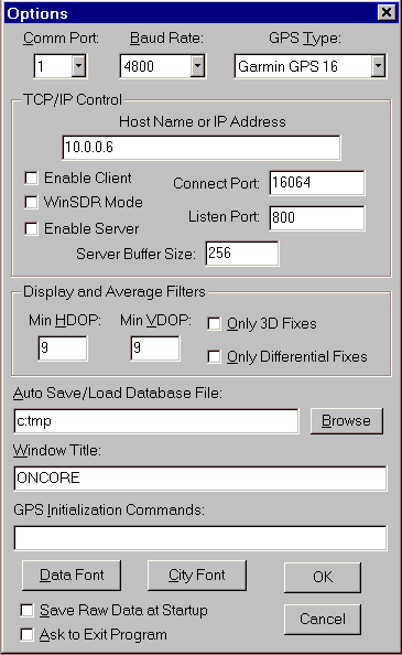
This dialog box controls most of the settings for the program. It is used to set the Comm Port, Baud Rate, GPS Receiver Type as well as other program settings. The dialog box is opened using the Settings / Options menu items or pressing the 'O' key.
Comm Port Select Box:
Selects the Comm port to use for the current active Map Window.
Baud Rate Select Box:
Selects the baud rate. Normally NMEA message are sent out at 4800 baud. The Motorola Binary format is always sent out at 9600 baud.
GPS Type Select Box:
Selects the GPS receiver type.
TCP/IP Control Group:
The controls in this group control WinPlotsGPS's TCP/IP Client / Server feature. This feature allows one copy of WinPlotGPS, acting as a server, to send data to a client. The client and be another copy of WinPlotGPS or a user supplied program that can open a TCP/IP connection and receive data through the connection.
Host Name or IP Address Edit Box:
Used when WinPlotGPS is placed in the Client mode. This is the host name or IP address of the WinPlotGPS server.
Enable Client Check Box:
Enable WinPlotGPS to act as a GPS data client.
Connect Port Edit Box:
This is the TCP/IP port number to use when connecting to the server. This number must match the server's Listen Port number.
WinSDR Mode:
Used to enable the WinSDR GPS data pass-through mode. More Information.
Enable Server Check Box:
Enable WinPlotGPS to act as a GPS data server.
Listen Port Edit Box:
This is the port to listen on for client connections.
Server Buffer Size Edit Box:
This edit box controls the packet size and how often a packet is sent. WinPlotGPS buffers the data from the GPS receiver. Then the buffer length reaches the number in this edit box, a new packet will be sent out. A small number will produce smaller packets more often, while a large number will produce larger packets but they will be sent out less often. Note, packets can be larger then the number specified in this edit box. This is because WinPlotGPS buffers whole GPS messages not one character at a time.
Display and Average Filters Group:
This group controls the filtering of the GPS position track points on the map. It also controls what data is used for the average position and height calculations. All information from the GPS is saved in the database. The filtering below only effects what points get displayed and averaged.
Min HDOP Edit Box:
Minimum Horizontal DOP (Dilution of Precision) number. The GPS receiver calculates and sends out a HDOP and VDOP number. with each position calculation. The lower the number the better the accuracy of the position and height information. Only HDOP position numbers below and equal too the number enter in this field will be displayed and used in the average calculation.
Min VDOP Edit Box:
Minimum vertical DOP number. Only VDOP numbers below or equal too this number will be used in the height average calculation.
Only 3D Fixes Check Box:
If checked only 3D fixes will be plotted or averaged.
Only Differential Fixes Check Box:
If checked only differential fixes will be plotted and averaged.
Auto Save/Load Database File Edit Field:
If this field contains a file name, the program will read this file at startup to seed the database. When you exit the program, it will save the current database to the file name.
Window Title Edit Field:
Changes the Map window title.
GPS Initialization Commands Edit Field:
Used to send one or more initialization commands to the GPS receiver at startup or when you use the Settings / Reset GPS menu items. Each command should start with a $ sign. Commands must be separated by a space.
Data Font Button:
Changes the font of the text on the left hand side of the Map Window.
City Font Button:
Changes the font of the city text in the Map Window.
Save Raw Data at Startup Check Box:
If checked, the program will save the raw data from the GPS receiver whenever the program is started up. Used in conjunction with the File / Save Raw Data menu items.
Ask to Exit Program Check Box:
If checked, the program will ask you if you want to exit the WinPlotGPS.
Ok Button:
Closes the dialog box. Any changes made will be used by the program.
Cancel Button:
Close the dialog box. Changes made to the settings are not used.
![]()
These menu items will be displayed when one of the Map Windows is active.
File:
Open:
Reads in a raw GPS data file or WinPlotGPS database file. Clears the current database before reading in the data. NOTE: After using this menu item the real-time processing of GPS data will be turned off. If you want to append new data to the database and have the information plotted on the map, you will need to use the View / Realtime GPS Data menu items.
Append:
Reads in a raw GPS data file or WinPlotGPS database file. Appends the data to the current database. NOTE: After using this menu item the real-time processing of GPS data will be turned off. If you want to append new data to the database and have the information plotted on the map, you will need to use the View / Realtime GPS Data menu items.
Save:
Saves the database to a file.
Save Raw Data:
When enabled, the program will save the data from the GPS receiver to a file. The raw data files can be view at a later time using the Open or Append menu items above.
Second Map Window:
Opens a second Map Window.
Exit:
Closes WinPlotGPS.
Calculate:
Average:
Recalculates the average position and height information.
Clear Average:
Clears the current average information. Does not clear the database information
Clear Average and Track:
Clears the current average information and GPS track display. Also clears the database information.
Clear Average and Track - Both Windows:
Same as above but clears both Map Windows. Only active if two Map Windows are opened.
Settings:
Options:
Opens the Options Settings dialog box.
Colors:
Used to change various map feature colors.
Distance Display:
Changes the Distance text information between Meters and Feet.
Height Display:
Changes the Height text information between Meters and Feet.
Speed Display:
Changes the Speed text information between km / hour and miles / hour.
Time Display:
Changes the time display between UTC or local time.
Reset GPS:
Re-initializes the GPS receiver. This feature only has an effect if a Motorola ONCORE receiver is being used.
View:
Redraw:
Redraws the map and GPS data points.
Move to Average:
Moves the center of the Map Window to the running average position.
Move to Location:
Moves the center of the Map Window to the current location calculated by the GPS receiver.
Display Average Point:
When checked the program will display a small circle at the running average position on the map. If two Map Windows are active you will see another square marked that displays the average position of the other Map Window.
Clear Track:
Clears the current GPS track data.
Draw / Clear Circle:
Draws a distance circle on the map.
Realtime GPS Data:
Enables or disables real-time GPS data processing. Real-time data will be disabled when you use Open or Append menu items or if the Comm port can not be opened.
View Messages:
Opens the Raw Data Viewer.
Pause Display Messages:
Pauses the display of the Raw Data Viewer.
Signal Level Window:
Opens the Signal Level Window.
Zoom:
Used to zoom the map in or out.
Window:
Used to Cascade or Tile the current open windows within WinPlotGPS.
Help / About:
Opens the About WinPlotGPS dialog box.
![]()
These menu items will be displayed when one of the Signal Level Windows is active.
File / Exit:
Closes WinPlotGPS.
Settings / Font:
Sets the satellite information font.
Window:
Used to Cascade or Tile the current open windows within WinPlotGPS.
Help / About:
Opens the About WinPlotGPS dialog box.