Last Updated: 03/14/2003
WinPlotGPS Version 1.5 can be downloaded here.
WinPlotGPS is a Microsoft Windows based program that displays the data from one or two GPS receivers on a map. This setup program will install the current version of program on your computer.
The program supports the following GPS receiver:
Motorola GT and UT ONCORE Receivers
Garmin GPS 16 Sensor
Or any GPS Receiver that can output the following NMEA messages: $GPRMC, $GPGGA, $GPGSA and $GPGSV
Version 1.1 Released 8/23/2002 - First Release
Version 1.2 Released 02/02/2003 - Fixed several bugs. The NMEA Message Viewer would not be visible after the program was minimized. Message View would automatically open at program startup.
Version 1.3 Released 02/09/2003 - Fixed a bug in the Signal Level window when displaying information from a ONCORE receiver.
Version 1.4 Released 03/02/2003 - Added TCP/IP Server / Client feature. Fixed a problem with resetting ONCORE receivers to the factory default settings using the Settings / Reset GPS menu items.
Version 1.5 Released 03/14/2003 - Added support to display GPS data from the PSN 16-Bit Serial Output Analog to Digital Converter board. See below for more information on how to use this feature.
After installing the the program and connecting up your GPS receiver to one of the comm ports on your computer, start program and then go to the Options Dialog box. This dialog box is opened using the Settings / Options menu items or pressing the "O" key. This dialog box is used to control most of the settings for the program.
The program can plot the data from one or two GPS receivers. To open a second Map window use the File / Second Map Window menu items. You will need two free comm ports to use this feature. After using the Options dialog box to setup the program you should see data plotted on the map and the text information on the left hand side should update as the data comes in from the GPS receiver.
To move around on the map use the mouse and double click on a location. That location will become the center of the map. You can zoom in or out by using the Zoom menu items or the PgUp and PgDn keys.
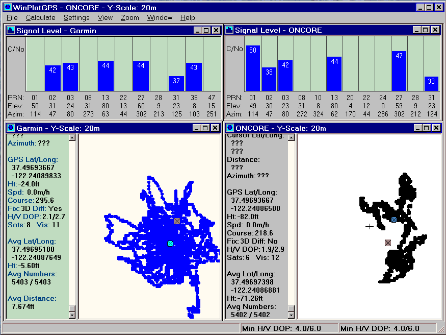
Each Map Window can have a Signal Level Window that displays information from the GPS receiver about the satellites that the receiver is currently tracking. See the first example image below. This window can be opened using the View / Signal Level Window menu items.
The Map Window can also have a GPS Data Points viewer open. This view displays information on one or more GPS data points on the map. Information displayed by this viewer includes the time, position, height, speed and course as calculated by the GPS receiver. See the second image below to see what this viewer looks like. This viewer is opened by using the right hand button of the mouse and clicking on a GPS data point on the map. Once opened, whenever you right click on a new GPS data point the viewer will be updated with all of the points at that X and Y location on the map.
The Map Window can have one more viewer opened that displays the raw data from the GPS receiver. This viewer is opened using the View / View Messages menu items. This viewer displays the raw MNEA messages from the GPS receiver or the binary data formatted to ASCII text if a ONCORE UT GPS receiver is used.
As WinPlotGPS receives data from the GPS receiver it parses the messages, stores the time, position and other information in a database and then plots the data on the map. This usually happens once per second. The database information stored in WinPlotGPS is used to redisplay the GPS data on the map. The database information can be saved to a file and later read back in. To save the database use the File / Save menu items. To load a database file use the Open or Append menu items. The Open menu item will first clear out the current database before reading in the file. The Append menu item does not clear out the database and appends the data to the end of the current database.
WinPlotGPS saves and reads files in several formats. As stated above, one of the formats is the database file format. When the program opens a file it checks to see if it is a database file, or a raw NMEA or Binary data file. It does this by checking the first character of the file. If the first character is a '$' the program assumes the file is raw NMEA data, if the character is a 'E" then the file is treated as raw binary data from a ONCORE UT GPS receiver. If the first character is a binary 3 the file is treated as a WinPlotGPS database file. The raw data messages from the GPS receiver can be saved using the File / Save Raw Data menu items.
WinPlotGPS can send and receive GPS data over a Local LAN or the Internet using a standard TCP/IP connection. When acting as a data server, up to four clients can connect to WinPlotGPS and receive data from the GPS receiver. Once the connection is established, all data received on the Comm Port will be sent out on the TCP/IP connection. Note, the connection is only outgoing . Data from the client will not be processed by WinPlotGPS or sent to the GPS receiver.
In the client mode, WinPlotGPS performs more or less as if it was connected directly to the GPS receiver, except it receives the data over TCP/IP rather then from the Comm port. One other difference is commands like Reset GPS will not work since WinPlotGPS servers do not pass on data from a client to the GPS receiver. Please see the Options dialog box for information on how to set up WinPlotGPS as a TCP/IP server or client.
To use this feature you must have the following equipment and software: A PSN 16-Bit Serial Output A/D Board with the current firmware (version 2.5 or higher) installed on the A/D board. A GPS receiver, either a Garmin GPS 16 or Motorola ONCORE receiver, must be connected to the A/D board. Note, SDR Server does not support this feature.
When this mode is enabled, GPS data received received by the A/D board will be first sent to WinSDR via the serial connection between the WinSDR and the A/D board. WinSDR is then placed into the TCP/IP Server mode so that WinPlotGPS can receive the data via a TCP/IP connection. WinPlotGPS can be on the same system as WinSDR or on another system on your LAN or on the Internet.
To enable the pass-through mode, open the Options dialog box and select the TCP/IP Enable Client and WinSDR Mode check boxes. You will also need to enter the Host Name or IP address of the WinSDR server system and the connection port to use for the TCP/IP connection. After closing the Options dialog box you may need to restart WinPlotGPS to establish the TCP/IP connection.
This image shows a huddle test of two different GPS receivers. One was a Garmin GPS 16 Sensor and the other a Motorola GT ONCORE GPS receiver. The Garmin receiver / antenna combination was placed about 1 1/2 feet from the antenna connected up to the ONCORE receiver. The two windows at the top of the image shows the Signal Level viewer for each map view. The map shows an area of 20 meters by ~16 meters. After 5400 averages the difference between the two averages was 7.67 feet. The small circle in each map is the location of the running average for the window. The small square shows the average location of the other window.
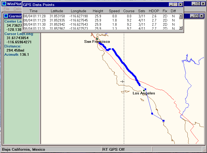
This image shows the data I captured while on a trip to Ensenada Mexico. We drove down Highway 5 to Los Angeles and then took a 3 day cruise to Ensenada. While we where out to sea I turned on my laptop and GPS 16 Sensor to capture some data. I also recorded data while we were leaving Ensenada. You can download the database file here. This image also shows the GPS Data Points viewer that can be opened by using the right hand button of the mouse and clicking on a GPS data point on the map.
This page viewed times since August 11, 2002